The Business Research Company’s report on the Mobile Mapping Market provides insights into the global market size, growth rate, regional distribution, competitive landscape, key segments, emerging trends, and strategic opportunities.
What are the primary drivers fueling the growth of the mobile mapping market in recent years?
Growing smart city projects are expected to propel the growth of the mobile mapping market going forward. Smart city projects refer to leveraging IoT and networking to make urban living more efficient and convenient through everything from smart traffic lights and data-driven energy efficiency schemes to electric vehicle charging stations and interactive kiosks that offer free broadband. Mobile mapping is helpful in integrating all aspects of city planning and management, coordination, and synergistic functioning of different participants of the smart city ecosystem. For instance, according to the Ministry of Housing and Urban Affairs, a ministry of the Government of India, as of November 2023, a there are total 7,947 smart city projects in India, out of which 6,196 projects are completed and 1,751 projects are ongoing. Therefore, growing smart city projects are driving the mobile mapping market
Access Your Free Sample of the Global Mobile Mapping Market Report – Get Insights Now!
https://www.thebusinessresearchcompany.com/sample.aspx?id=6328&type=smp
What is the projected market size of the mobile mapping industry, and how is it expected to grow?
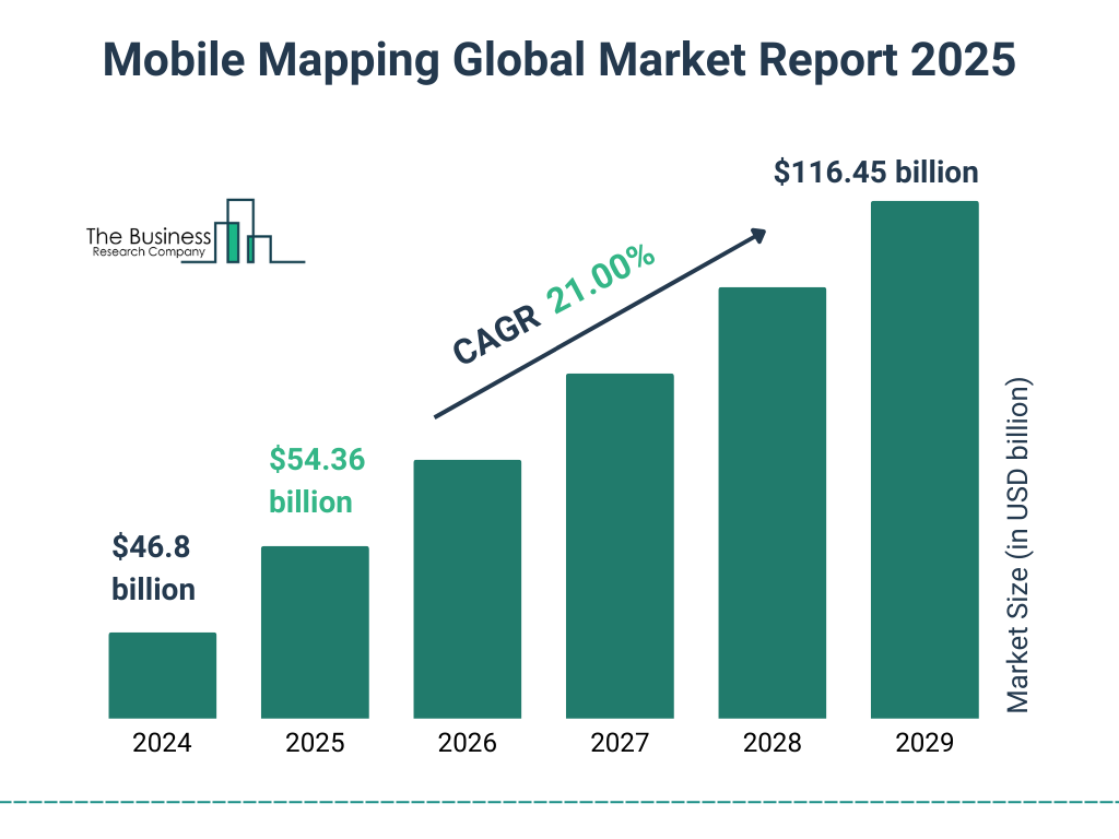
The mobile mapping market size has grown rapidly in recent years. It will grow from $46.8 billion in 2024 to $54.36 billion in 2025 at a compound annual growth rate (CAGR) of 16.2%. The growth in the historic period can be attributed to transportation and navigation applications, infrastructure development projects, asset management and inventory, rising demand for 3d mapping, urbanization and smart city initiatives.
The mobile mapping market size is expected to see exponential growth in the next few years. It will grow to $116.45 billion in 2029 at a compound annual growth rate (CAGR) of 21.0%. The growth in the forecast period can be attributed to environmental monitoring and conservation, precision agriculture, indoor mapping and navigation, tourism and location-based services, humanitarian aid and disaster response, customized mapping solutions. Major trends in the forecast period include integration of lidar technology, advancements in sensor technologies, increased adoption of 3d mapping, real-time data capture and processing, cloud-based mapping services.
Gain Exclusive Market Insights—Customize Your Research Report Today For Fast Delivery!
https://www.thebusinessresearchcompany.com/customise?id=6328&type=smp
Who are the key players driving competition in the mobile mapping market?
Major companies operating in the mobile mapping market include Apple Inc., Trimble Geospatial, TomTom N. V., Mitsubishi Electric Corporation, Topcon Positioning Systems Inc., NovAtel Inc., Garmin Ltd., Google LLC, Microsoft Corporation, Qualcomm Incorporated, Telefonaktiebolaget LM Ericsson, Leica Geosystems, FARO Technologies Inc., Trimble Inc., Hexagon AB, NGC Aerospace Ltd., IGI GmbH, Huron Geomatics Inc., The Sanborn Map Company Inc., Javad GNSS Inc., Teledyne Optech, Imajing SAS, Cyclomedia Technology BV, INRIX Inc., Baidu Inc., Black and Veatch, Four Square Labs, MapQuest, Foursquare Labs, Mapbox, Esri
What key trends are expected to drive the mobile imaging services market during the forecast period?
New product innovations have emerged as a key trend gaining popularity in the mobile mapping market. Major companies operating in the mobile mapping market are focused on new product innovations to strengthen their position in the market. For instance, In April 2022, Topcon Corporation, a Japanese manufacturer of optical equipment, launched the IP-S3, the latest edition 3D mobile mapping system. The IP-S3 is smaller and lighter than earlier models, and it scans up to five times faster. The system integrates an Inertial Measurement Unit (IMU) and GNSS receiver with a vehicle’s onboard electronics to provide high-density mobile digital photography. The software suite used provides an all-in-one processing workflow that transforms raw sensor data acquired by the IP-S3 system into rich and precise point clouds and pictures.
Which key geographies are driving the growth of the mobile mapping market?
North America was the largest region in the mobile mapping market in 2024.The regions covered in the mobile mapping market report are Asia-Pacific, Western Europe, Eastern Europe, North America, South America, Middle East, Africa
Order Your Report Now For Swift Delivery
https://www.thebusinessresearchcompany.com/report/mobile-mapping-global-market-report
What are the key segments driving growth in the mobile mapping market?
The mobile mapping market covered in this report is segmented –
1) By Type: 3D Mapping, Licensing, Indoor Mapping, Location Based Services, Location Based Search
2) By Component: Hardware, Software, Services
3) By Application: Road Surveys, Topographic Mapping, 3D Modeling, Asset Management, Other Applications
4) By Industry Vertical: Oil And Gas, Real Estate, Telecommunication, Manufacturing, Transportation And Logistics, Energy and Utilities, Other Industry Verticals
Subsegments:
1) By 3D Mapping: Point Clouds, Digital Elevation Models (DEMs), Digital Surface Models (DSMs), 3D Models For Urban Planning, 3D Models For Construction
2) By Licensing: Software Licensing, Data Licensing, Application Licensing, API Licensing
3) By Indoor Mapping: Floor Plans, Navigation Solutions, Asset Tracking, Space Management Solutions
4) By Location-Based Services (LBS): Geolocation, Proximity marketing, Fleet Management, Mobile Payment Services
5) By Location-Based Search: Local Search Engines, Augmented Reality (AR) Search, Voice Search Services, Map Integration Services
Purchase The Exclusive Report Now To Unlock Valuable Market Insights:
https://www.thebusinessresearchcompany.com/purchaseoptions.aspx?id=6328
How is the mobile mapping market defined, and what are its core characteristics?
Mobile mapping is the process of collecting geographical data with a mobile vehicle equipped with a laser, GNSS, LiDAR-system, radar, photographic equipment, or any number of remote sensing devices. These georeferenced data points can also be utilized to construct accurate three-dimensional digital elevation models (DEMs) or digital terrain models of any environment when combined with positioning equipment. It is used to collect geospatial data from mobile vehicles such as cars, drones, and boats.
About The Business Research Company:
With over 15000+ reports from 27 industries covering 60+ geographies, The Business Research Company has built a reputation for offering comprehensive, data-rich research and insights. Armed with 1,500,000 datasets, the optimistic contribution of in-depth secondary research, and unique insights from industry leaders, you can get the information you need to stay ahead.
Our flagship product, the Global Market Model, is a premier market intelligence platform delivering comprehensive and updated forecasts to support informed decision-making.
Contact Us:
The Business Research Company
https://thebusinessresearchcompany.com/
Europe: +44 207 1930 708
Asia: +91 88972 63534
Americas: +1 315 623 0293
Email: info@tbrc.info
Follow Us On:
LinkedIn: https://in.linkedin.com/company/the-business-research-company